No— the coasts have substantially higher property values. A cartogram scaled by population is far less dramatically distorted:
http://www.esri.com/news/arcuser/0110/graphics/cartogram_3-l...
The big cities of Texas and the Great Lakes regions barely show up on the property value map.
Roughly that's all it's showing. I'd be far more interested in the cartogram of land value/population. I suspect it would do much more to show some of the oddities that I'm sure exist. (i.e. Park City where a lot of people have really expensive vacation homes for skiing and don't live there.)
I wonder if it should be normalized by population or population density. I think population density would show the most interesting market divergences.
Not quite fair. Usually the xkcd syndrome is caused by plotting density of something that is intrinsic to people e.g. red hair. You end up with a heatmap of population.
Here, land prices may be higher because more people are there bidding up the prices. But its not a direct property of the individuals. So the heatmap effect is indirect.
This map is measuring the land value within a county. Land values are dependent on population density. It's not surprising that Manhattan has such a high value when you consider how many folks are crammed into the island.
If you create a map that was land value divided by population density it would be much more interesting.
Exactly. This is making Dallas County look expensive, when in fact it is one of the most affordable major metro areas in the US.
The "elite Texas counties" the article refers to are really a figment of data representation. Sure, those counties have neighborhoods or small towns that are stupid expensive, but they are the exception. All of them are highly populous, though; all five dark red counties (Dallas, Tarrant, Harris, Travis, Bexar) are in the top-20 most populous counties in the US.
The data is purporting to show total property value, not land value. Thus, a residential tower with 400 units at $100,000 each and occupying five acres adds $40 million to the valuation. In contrast, a five-acre spread with a single mansion might only be worth $5 million. Thus, a county with more residential towers will have a higher aggregate value than a county with more luxury mansions, even though the former is much more affordable.
The map shows total land price in the county. It doesn't measure anything like affordability of land (which would be measured by something like price / unit area of land) or residential affordability (which would be measured by something like price / unit area of home.)
> This map is measuring the land value within a county. Land values are dependent on population density.
Not strictly, though population density is certainly a factor (and, since its total land value in each county, so is population, which -- as counties are not of uniform size -- is a separate concern from population density. And, probably more directly than either of those, Gross County Product.)
Not to be pedantic, but I think your example is a little off the mark. Red hair isn't evenly distributed amongst all human populations. [1] A heatmap of population that would leave out most of China and India isn't quite a heatmap of population.
No, unless I'm mistaken, it's literally the sum value of all the bare land, not including the value of the buildings. California seems to have a third of value in the United States, and the Northeast Corridor has another third, but neither have a third of the population.
(edit: I stand corrected, but it's still notable that property value and density aren't necessarily correlated.)
The source article is complaining about a $100 million condo in NYC that is listed at $6 million, and it pulls the values for the rest of the country from the Census (which tends to track households more than properties), so I think it is just the opposite, it mostly reflects the value of buildings.
If you follow the one of the links in the story, you'll see that one of the reasons the housing prices in NYC and SF are so high is the unwillingness of current residents to allow more construction to allow greater housing density. So, in this case, it isn't a proxy for population density since the high prices are actually a symptom of below-optimal population density.
That doesn't quite follow since SF and NYC are already the highest population densities in the US. The fact that the residents don't want to allow greater densities doesn't invalidate the correlation.
Yes, it does. Demand is very different from density. The fact that one region happens to have both high density and high demand is coincidence, not correlation. For it to be a correlation, that would have to be the case in most places. Places like Mountain View, Palo Alto or even Beverly Hills and Malibu also have high demand with a much lower population density.
Also, while it's trite to say, correlation doesn't not mean causation. Being a proxy means a causal relationship, not just a correlation. XKCD was arguing against maps that indicate a causal relationship. Each of the graphs in the comic don't just correlate with population density maps, they're the same because they're visualizing a trait that has no difference based on geography. That's in no way the case in this situation.
After two years of analysis, West and Bettencourt discovered that all of these urban variables could be described by a few exquisitely simple equations. For example, if they know the population of a metropolitan area in a given country, they can estimate, with approximately 85 percent accuracy, its average income and the dimensions of its sewer system. These are the laws, they say, that automatically emerge whenever people “agglomerate,” cramming themselves into apartment buildings and subway cars. It doesn’t matter if the place is Manhattan or Manhattan, Kan.: the urban patterns remain the same. West isn’t shy about describing the magnitude of this accomplishment. “What we found are the constants that describe every city,” he says. “I can take these laws and make precise predictions about the number of violent crimes and the surface area of roads in a city in Japan with 200,000 people. I don’t know anything about this city or even where it is or its history, but I can tell you all about it. And the reason I can do that is because every city is really the same.”
It's related to population density. A lot more people want and try to live in NYC than Birmingham, AL. More people living and desiring to live per same square mileage ~ increased price of property.
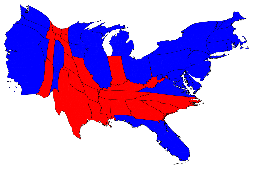
This is electoral votes per county, which is close to being population-weighted. What you'll find is that it's more moderate than the land-value cartogram, especially on the West Coast and Florida. Land values trend similarly to population densities, but actually exceed them.
Given that the data are by county and electoral votes aren't allocated on a county basis I'm going to walk back from what I wrote. The source isn't clear on basis though I suspect it's actually population.
Each state gets a number of electoral vote that matches the number of Representatives and Senators in their state. The senator thing throws it off a bit, but number of reps is based on population.
No, it's not that close. The small number of reps plus the huge variation in state sizes means that it's not particularly close even before considering the distortions from Senate seats. There is, IIRC, almost a 2:1 ratio between the maximum and minimum population-to-representative ratio among the states.
This used to be true because, as more population was added more Representatives would be added to the House, but as I recall it's been quite a long time since new seats were added to the House.
Not quite... If that were so, you'd expect Texas to be visibly bigger than Florida (27M vs. 20M), but their area in the distorted land value map appears to be about the same.
Florida is much more likely to have "exiles" from more expensive regions of the Northern Atlantic Seaboard living there, driving up prices. You'll have wildly varying prices not that far apart in Florida.
Why are you comparing Santa Barbara county to the city of Des Moines?
Des Moines is in Polk county with a density of 751/sq mi.
Anyways, I was just pointing out that your answer of "no b/c Iowa has 3 million people" has nothing to do with population density as the question posed.
Why are you comparing Santa Barbara county to the city of Des Moines?
Size on the map is calculated as the sum (property value).
If we chose Des Moines to arbitrarily be a county then its population density would be really high, but it would be an even smaller chunk on the map.
Sure, you might be able to get a reasonable approximation of that map from: population * population density per mile, but population density on its own is not going to get there.
PS: As to why I said mentioned the population of Iowa in the first place, XKCD was a map of population per area. If you scale the map based on population and ignore area then it's just a population map. http://www-personal.umich.edu/~mejn/election/2012/statepop10... Note the west coast is 1/2 the size of the east cost, and texas is about the size of california.
> The demand to live in these places is soaring, but the desire among incumbents to accommodate newcomers is low
Sums up why we ended up in Bend, Oregon rather than Boulder, Colorado. In the latter, there is a small but significant group of people whose idea is that the area needs fewer jobs, not smarter housing.
As a lifetime Oregonian, I enjoy Bend and get out there a couple times a year. My family even considered moving there a few years ago in search of a place with more sun. But in deciding between Boulder and Bend, we ended up choosing Boulder, well actually Broomfield, but Boulder was the draw, because as you found Boulder housing prices were too high.
Which leads me to the question, did you consider living outside of Boulder to still get most of the things on your checklist, but not face the high housing prices or difficult political climate?
The problem with Bend, as we came to decide, was there is no "outside of Bend", it's an island with not much of any other place to go for jobs, housing, diversity. Add in the fact that the jobs that are there don't support the house prices. With Boulder, you can always fall back to Denver or one of the many suburbs if your independent business or remote job falls through.
We ultimately moved back to the Portland area for other reasons, but would still choose Boulder/Denver over Bend if we had to do it again.
> did you consider living outside of Boulder to still get most of the things on your checklist, but not face the high housing prices or difficult political climate?
Yeah, but at that point, you're back to the whole car commute thing, or a really long bike ride. And you're significantly farther from the mountains by bike, too.
Fort Collins was something else that looked pretty interesting, but I didn't see many jobs there.
> there is no "outside of Bend"
Yeah, that's something we're nervous about, and definitely a point in favor of Boulder. OTOH, Bend does seem to be growing - they're building the new university now, which should help a little bit.
> the jobs that are there don't support the house prices
I got lucky from that point of view, I guess.
Speaking of stopping by, I'd be happy to meet up with people for beer or whatever as soon as we're slightly more settled in.
> Yeah, but at that point, you're back to the whole car commute thing, or a really long bike ride. And you're significantly farther from the mountains by bike, too.
Ahh, right, car-free commute is a good point.
> Fort Collins was something else that looked pretty interesting, but I didn't see many jobs there.
My reaction to Fort Collins was similar, really liked it too, but seemed more like Bend as far as lack of jobs/backup-plans go. I like smaller cities and I work remotely, so backup plans shouldn't matter as much as it does to me. I'm probably too risk-averse in that sense, as I also had the same fears when looking at a move to Corvallis before. I suppose I'll always need to be near a bigger city to compensate.
There's a small tech scene in Fort Collins, mostly focused on hardware. Intel, HP, AMD, Broadcom, Avago, LSI, and Microsoft come to mind. (Well, three of those are now one)
A small market like that is good and bad. There is no glut of engineers, so you aren't a cheap throwaway commodity, but options are fewer.
You could use Boulder/Denver/Longmont as your fallback. A sizeable commute, but that adds IBM, NASA, Western Digital, Xilinx, Avaya... and a host of startups.
The real startup scene in Fort Collins is probably microbreweries. Engineers of every type are starting microbreweries.
Curious to know in what ways you think so? Not that I disagree. I was at the intersection of Broomfield/Erie/Lafayette and we spend much more of our non-being home time in and around Boulder, Lafayette and Louisville than Broomfield. So, while Broomfield was our residence, Boulder was still the draw.
I used to live in Lafayette and definitely agree- the only reason we lived in Lafayette vs. Boulder was the housing was much more affordable. The town is pretty quiet but we would always drive up to Boulder if we wanted to hang out or do something fun. Denver wasn't too far away either, so we would go there for concerts or conventions or whatever.
I moved out to Oregon and live in the Salem area for a similar reason- the housing is much more affordable here than in Portland. I'm about an hour from Portland and an hour from the coast, so we split our time up between the two.
"lively" Boulder is a bland white town full of people who are almost exactly the same. They are awesome, granted, but there's little to no diversity here. The college kids are mostly wealthy out of staters whose parents can afford to pay 200000+ for an ok state school. Most come here to play hippie, snowboard, and party.
Boulder is hippies with breast implants. Beautiful, wealthy, educated people who want to isolate themselves off from the rest of society. People here are very bland. There is next to no nightlife. Bleck, what a disappointment.
Really nice piece. I basically moved from SF to Boulder (with stops abroad in between). What you're talking about in the blog is playing out right now with the "make growth pay it's own way".
They are smart people spearheading these anti-growth measures. They want (like you said) the Boulder from 30 years ago. They are motivated, smart, and have the time to attack growth.
And cutting back on construction is only going to turn this place into more of bland sanitized white suburb college town. There's little to no culture or character or funkiness here and cutting off growth will only serve to stamp it out more.
People here like to say silly things like "entrepreneur capital of america" or "startup hub" or silly things like that. Shoot, coming from SF, this place doesn't have even a drop in the bucket of what the bay has. I'm not saying that's bad or good but thinking it's a real tech hub is a joke.
Note: Boulder is great if you already make good money, like a small quiet life, have your partner, and value access to nature over access to people, music, culture, art, etc.
But if Boulder looked more like Denver (or Bend like Portland), you might not have made that choice, right? I'm guessing that you wanted those spots because they were semi-rural mountain cities with low population density.
So even if you did move to Boulder, you'd probably oppose the construction of more high-density housing, right?
There are smart ways to do high-density housing while preserving the character of cities like Boulder. The rail line from Denver to Boulder is going to help a lot of people justify not having cars in Boulder, and traffic congestion is probably the most harmful effect of squeezing lots of people into a small space. There are lots of places east of downtown/CU that you could build clusters of high-density, 4-5 story, mixed-use residential that wouldn't obstruct mountain views for the most powerful (i.e. richest) homeowners in Boulder. It would look ugly if you did something like the Denver Tech Center where 15-25 story buildings are placed on a ridge on the plains with no trees, but you could conceal quite a bit with the right placement of native trees around smaller 4-5 story buildings.
I want to live someplace that's not too big in area, actually. Padova (where I've spent most of the past 15 years) is actually about the same size as Boulder, and has more than twice as many people, and I liked it just fine.
What I want is to live within biking distance of where I work (10 minutes today - yay!), as well as be able to ride my road and mountain bikes, and have other outdoor stuff close by. In Boulder, to get something affordable, you need to live in one of the nearby towns, which means either an hour by bike, or a drive. Thus - for me - defeating the entire purpose of not living in a big city.
I like density in other words, as long as the total population is not too high.
Denver isn't exactly great at the moment either. However, we've taken a more proactive approach by building more housing instead of trying to keep people out.
How are you liking Bend? I remember reading some of your comments on HN a few years ago since we were living in Portland. In Seattle now and own a place, but are thinking someday we might sell it and move to Bend. We've always found central Oregon uniquely beautiful. My friend just bought a place in Boulder, and I visited and enjoyed hanging out there. Things did seem a bit more expensive.
Up: Bend is a rad place. The lazy river / float scene is really fun. There are approx. 26 breweries, great food, and a really active community. On a typical weekend everyone is out and about which makes it easier to meet folks and get integrated into the community.
Down: Bend was not built for the massive influx of people that the city has seen in recent years. The transportation group is trying to work through it but they will need to be very creative as there is a nice distance gap between East Bend and West Bend.
There are also lots of traffic circles that are single lane that seem to slow down traffic (good and bad) but they run right up against homes and businesses so there are not many options for expansion.
If you own in Seattle now is a great time to sell. We moved a year ago (enjoyed Seattle and its quirks/beer/outdoors) to a more Bend-like community and run our business from here. The transition was worth its weight in gold and we don't look back one bit.
Why is everybody mentioning Bend? Is there a big tech scene there? I used to live in Colorado so I know there's a lot of tech companies in the Boulder area, but I've only been living the the PNW for a few years and haven't heard much about the technology scene here other than everything up in the Seattle area (Microsoft, Amazon, Boeing, Valve, etc.)
Summer in Oregon is wonderful, no two ways about it. What we'll have to see is how the winter is over here. I grew up in Eugene and lived in Portland, and just can't handle that endless gray.
Hopefully we get back to the "normal" Summer in Oregon relatively soon (not looking likely thanks to the Blob/El Nino). Living in Portland without an AC this Summer has been terrible.
From your blog, it looks like you were pricing sizable houses rather than higher density housing like a 2br/2ba condo, which can be found for much less. Although I grew up in Alaska, I have no regrets about buying a modest condo next to trails and with a short bike commute instead of a larger place further from everything I care about. Anyway, there would be more incentive to build high-density housing if more people wanted to buy it instead of writing off the housing market as insane and going elsewhere (be it the eastern suburbs or somewhere completely different as you did).
Prices are lower all across the board in Bend. We were looking into some townhouses in Boulder, and they're still several hundred dollars more than what we pay in a nice part of Bend within walking distance of downtown.
Obviously, but no amount of high-density construction in Boulder will make it cheaper than equivalent accommodations in Bend (unless Bend gets a lot more expensive).
I'm not questioning your decision, but it's worth being realistic about what high-density construction could achieve.
Even though there does seem to be a large influx of people in cities like SF, NYC, Austin, it seems like there is going to be an even larger exodus to smaller towns with sane costs of living in the coming years. It could also be my that my friends are all also finally entering the age where we want to buy homes, so these sorts of places are more appealing than ever.
Bend is lovely. I'm curious, what was it like finding a place to live? Bend is somewhat notorious right now for it's <1% rental vacancy rates, which may be the lowest in the country. There was a news story earlier this year about a local medical center's new hires having a hard time finding a place to live -- I think one person even gave up and left their job because of it.
How can the random large splotches be translated into usefulness or meaning? The gif seems to imply that the areas are resized based on their value, that is SUPER not helpful. And the bucket $40b - $1tr?! Almost everything falls in that bucket! I don't think this map is of great value.
I thought that bucket was large too, but then I realized it is only used for color, not size. So size of county is a more granular measure for housing measure, if that's what you're looking for.
EDIT: I see, you're saying the areas are hard to compare. Good point!
Totally agree. It's easy to understand the implications but as a New Yorker it's hard not to be proud of your city in some ways. The UES being worth more than six states, it just boggles the mind to try to do the comparisons in your head.
LA county has almost 10M people living in it. SF has only 800K. If housing prices were equal, you'd expect LA to be 10 times the size (assuming an equal number of people per dwelling).
Yes, it's difficult to make a fair comparison across counties of such vastly different areas and populations. LA county includes far-off places like Palmdale which bring the average housing price way down. If you only looked at more central neighborhoods like Hollywood, Beverly Hills, Santa Monica, etc. you'd see distortion more akin to SF.
The fact that people don't all prefer everywhere equally is a "troubling inequality"? Property value is just a reflection of demand vs. supply. People want to live in some areas of the country more than in others, but, since the area is limited, the increased desire drives prices up.
Is it really so shocking that more people would rather live in San Francisco than Alabama?
>Folks who can’t afford to live in those places don’t get to take advantage of those labor markets. The demand to live in these places is soaring, but the desire among incumbents to accommodate newcomers is low. Hence NIMBYism, high housing costs, severe inequality—the whole shebang.
NYC has had a massive residential construction boom (see Williamsburg, downtown Brooklyn, Long Island City, &c). Almost all of the housing that goes up is luxury and seems to do very little to bring down the city's extreme housing costs. Maybe severe inequality is driven by factors other than just NIMBYism? The new condos seem to attract wealthy outsiders.
From the standpoint of at least one "user", I would have gotten a lot more value out of the animation if I could control it (e.g. with a slider). The pulsing back and forth makes it more difficult for me to pinpoint something of interest (e.g. a less expensive city like Detroit) and then track it.
Going down into the rabbit hole, here is a JSON file [1] containing the county level data from the Economist. I think that this is the source of the data used by the author.
The conclusions from the article seemed a bit rushed. NYC and the Bay Area are pretty different when it comes to NIMBY policies and commutes from low income areas to high income.
In NYC if you need a $1200 / mo 1BR apartment, sure Manhattan and north eastern Brooklyn aren't options but you still have places like Harlem, Queens, New Jersey, The Bronx, Staten Island all of which are under an hour commute from Manhattan (and with a rapid transit system that respects shift workers by running 24hrs a day).
NYC has also been adding high density (albeit market rate) housing stock by the tens of thousands each year since 2013 or so. NIMBY-ism in Bay Area communities tends to be opposed increased density of any sort, but for the most part in NYC it's focused more on the boundaries of low income housing areas.
East coast municipalities also have a lot more power to make mandates without the kind of broad community consensus that California cities have to abide by. So while residents can express opposition to a development plan and sometimes fight it in NYC, NIMBY advocates only carry weight when they're well equipped to battle city hall.
Basically my point is that it's kind of a stretch to draw a conclusion that the same patterns are applicable to both housing markets. The New York metro and the Bay Area metro are very different places with very different policies and political landscapes. New York's inflated housing market has more to do with legacy policies from the Bloomberg administration and real estate speculation than too few units and NIMBY attitudes, which are a much bigger problem in SF
I don't want to get drawn into a long debate on it, but I think it's clear that NYC has competitive commute times to the Bay Area. Some even think it's worse:
As far as NIMBY goes... I guess I was taking that more broadly. There isn't objections against density qua density, but projects are blocked because they block views. And projects are blocked because of what they'd do to the neighborhood (think highways and housing projects, Forest Hills as a popular counterexample).
There also seems to be some empirical evidence that NYC is actually building housing slower than SF.
Both of those articles are a good illustration of my point actually, sensational conclusions drawn from reports that don't take into account the dramatic differences between the cities being compared. In this case, NYC is so enormous that it's in another weight class where the benchmarks we're being presented are highly flawed in context.
For example, the commute time piece in Fortune isn't looking at metro area, only intra-city commute time. NYC having the longest average commute makes for an interesting data point and it's technically true, but it doesn't take into account the fact that the city of New York has an extremely large land area spread across several islands with a population that dwarfs most of the cities on that list. Considering how the data for NYC is influenced by situations like the non-trivial number of Staten Islanders who commute 1 to 2 hours a day to Manhattan (still intra-city) via ferry + subway, the 31.5 minute average commute time in SF doesn’t look so good. Painting these pictures with the same brush is an effort in futility, the same standards just don’t apply
A well-known prior art of this idea -- and perhaps not even the first -- is Worldmapper at http://www.worldmapper.org/. "The world as you have never seen before" contains striking world maps with their areas proportional to measures like population (even the population in AD 1), income, aircraft flights, toy exports, nuclear weapons, languages, people killed by floods and 600 more.
i kind of understand why people here frequently against high-density - the way it is done in US ends up with pretty unlivable space of towering boxes surrounded by concrete and asphalt (which is just obvious result of profit maximization while obeying height limits, etc.. While i think having a 200 stories tower surrounded by a park would be better than a bunch of 20-30 stories mid-towers sticking out of concrete/asphalt space)
I feel that sound is a big part of it too. European buildings tend to be a titch bit better about this, but American ones are downright terrible. I'd love to live in a apartment building for a long time, but the sound is what gets me. I can't play my sound as loud as I want, I can't stand other people ignoring that the walls are paper thin, I hear every toilet flush and chopping of carrots in the building. If you can find a way to really dampen the sound, then I feel a lot of people wouldn't mind the high density quite as much.
That doesn't have to be the case... I live in a large apartment building on a high floor, and I rarely hear my neighbors. Good walls and smart design go a long way. Granted, this is a fairly new building that is a bit expensive, but my point is that noise problems in high rise buildings aren't inherent to all large buildings.
This is honestly one of the big things that turns me off of high density here. I feel like I am losing privacy and having to walk on eggshells constantly to avoid pissing off my neighbors.
>While i think having a 200 stories tower surrounded by a park would be better than a bunch of 20-30 stories mid-towers sticking out of concrete/asphalt space)
Ugh, please no. This is essentially what Le Corbusier advocated and the results are disasterous. It leads to all of the downsides of density. Lots of people taking up space, but none of the benefits (easy access to shopping, entertainment, school, work, etc.), because everything's so damn far away from each other.
> "The stubborn unwillingness of incumbent homeowners in highly productive places—namely San Francisco and New York City, which are barely visible on the land-area map, but dominate the housing value map—is a huge drain on the nation’s economy." Are they trying to say that if people didn't have to spend as much on housing then there would be greater GDP?
I think that if rents weren't such a drain, then yes, you could spend the money on other things and drive up GDP. SF currently has bad rents that are hurting the local economy. Money that just a few years ago was going to eating out, new cars, vacations, etc. is now going to a greedy landlord.
I think he is alluding that high rent leads to wealth concentration. A lot of salaried people can invest a tiny bit in a much larger variety of interests than a few wealthy, or choose to work on something less profitable while still making rent. These investments by a lot of people will at some point lead to unexpected value creations that increase GDP. At least that is the tenet of a consumer and market economy.
Housing is an input to productive, primary industries, and local politics conspire to keep the housing supply low and price high. This makes operating the productive industries more expensive. Similar to energy prices on manufacturing industries - high input cost -> lower productivity.
No, it's saying that concentration of wealth geographically is harmful to economic development. The reality is though, that distributed wealth grows much more slowly.
That's not even close to what it's saying. It's saying people in places like SF don't want others coming in/and or want to maximize their home value, so they stop new housing being built, which keeps supply of housing down and thus less people can live in areas where there are lots of work opportunities.
You're thinking too narrowly. Your point is correct, but the broader point is that there should be those same work opportunities spread out around the country so that you don't have to move to SF or wherever to get a good job. That is what hurts the economy on a broader scale.
Employment is "sticky" in that personal mobility can't move as fast as capital mobility and that seems to have led to concentrations of wealth.
There is nothing in this link about personal attacks. "Be civil" is as close as it gets. "you're thinking too narrowly" is only slightly less civil than "You are literally clueless", which is something people say, face to face (see the bit after being civil?), frequently.
The statement "you are clueless" in response to "you are thinking too narrowly" is hardly the "height of incivility", especially when the comment of thinking narrowly was off base by a long way. The word "civil" is hardly well defined in the first place.
You are wrong, didn't take into account the context, pulled the trigger too quickly, and now won't back off of it. This is the worst type of moderation.
The author might be making a valid point, but the visualization they chose doesn't match their thesis very well.
Think about it: if the homeowners in SF relent, approve massive housing projects, and decrease the average housing price of SF, then more people will now move into SF and its total real estate price (and hence the size of SF in their visualiztion) will increase.
Not necessarily. SF has a housing shortage. Remembering our basic supply & demand curves, price starts to go up exponentially when demand greatly outstrips supply.
Suppose you met the demand by doubling the supply. Suppose that takes you out of the exponential region, and housing costs drop fourfold. Overall, the market shrinks by half.
Maybe that's what they are saying. I could understand this wrong but high real estate prices locks up a lot of wealth in property where it isn't really doing any good. If all that wealth was able to circulate in the economy, it might increase growth.
You might argue that when I buy a house for $500k, the seller gets $500k, so where's the problem? But the seller needs somewhere to live too- they are probably putting that $500k into another house, commonly an even more expensive house.
That implies that all the cash is getting sunk into a new place, which is typically not the case.
Typically, I'm only putting 20% of that $500k down on the property. Now, to be fair, that $100k is effectively mothballed unless I pull it out with an equity loan or somesuch, but that's a far cry from freezing $500k.
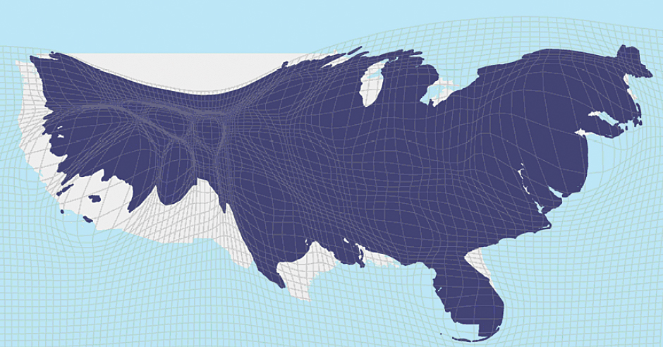
I'm guessing you generate these by fixing three points along the boundary and then find the conformal map with the prescribed scale ratio at each point. Cool tech. If only this was a useful way to present the information. Color contours work much better.
I can't help thinking this trend is at its zenith. Where economic growth is faltering, we're seeing de-urbanization, and I would be long the yellow areas and short the red, because if there is any upset to the JIT way our cities operate (London for example is said to have a mere 4 days worth food in stock), for reasons of climate change or political upheaval or some other reason (no more opportunity in overcrowded cities?), the rural areas on which we still enormously depend for food and water may suddenly revalue upwards.
Look outside the US. The US is not anywhere near as distorted as several asian countries and even mexico has a more extreme situation. Asia suggests it's not even close to it's zenith
This appears to be housing value, not property value. So this is leaving off commercial property, which is probably usually proportionate to housing value, and agriculture land, which isn't.
It would be interesting to see areas cross referenced by job creation and relative affordability over time. Perhaps there are counties whose plans did provide growth without economic isolation?
You'd also need to reform the way school districting works. Well, I guess it could cause another round of suburban flight of the affluent, but the underlying problem would still be there.
Awesome idea! If they could make it less ugly, I would prefer standardizing on this as a way to plot geographic data in certain cases.
Graphing by land area often means spending huge chunks of the map where nothing (relevant to a particular purpose) happens, and cramming all the interesting stuff into a few places on the coasts.
(Note all the hedges and caveats; I don't want to trivialize anyone's home here, but we definitely see this effect a lot.)
While it looks extremely cool, is this really the best way to visualise this data?
Every method of visualisation has its strengths and pitfalls. One of the pitfalls of this method is that it always looks rather dramatic, regardless of the data. Changing the shape of well-known things gives an uneasy feeling, regardless of what you map.
Only data that is perfectly equal will not result in arbitrary distortions. The amount of distortion, magnitude of the local scale factor, is (or should be) a parameter of the visualisation, just like the decision of using a fiery red-yellow colour gradient.
Linked source has a bit more info on what exactly they did. Which is simply substituting area for value in dollars. Only makes sense if the data somewhat follows a normal distribution. And I'm going to guess here, property value does not, at all. It's not even bounded. I'd have picked log value, because an exponential distribution for the value is a much more reasonable assumption.
In case of a visualisation like this, I might actually decide to do something that is generally frowned upon: change the "origin" of the data. That is, add some constant value to the scale factors, to smooth out the severity of the distortions a little. If I were mapping the log value that wouldn't be necessary since it'd be equivalent to scaling dollar values to $1000 or $1M, etc.
I'm trying to remember other examples where data was mapped to local scale in a non-shape preserving way.
The only thing I can come up with was a sort of homunculus visualisation (I forget if it was just a drawing or actually made into a 3d clay statuette). It scaled our body parts roughly proportional to the volume of our brain dedicated to it. So you'd get a giant head with huge bulging eyes, etc. It looked weird, funny, still somewhat human/cartoonish. It showed things as "this is MUCH bigger than that" or "huh I didn't realise my tongue was that important". It wasn't a very clear visualisation, but I'm also hard pressed to come up with a better way to do it.
In other words, this type of visualisation helps to show the data in a mostly qualitative way, not quantitative. And like the homunculus example, the data doesn't need to be super exact (we can't estimate relative area/volume of irregular shapes very well).
I'd love to see this for Australia, so much of the population is in like 5 cities it would just look like one of those plastic ball molecule model things
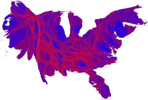
I don't think I've ever seen a worse Cartogram. At least they did an animation to make it easier to understand, but a regular map with simple choropleth would be a thousand times better.
I think the animation turns it from one of the worst visualizations I have ever seen to one of the best. Its point is ultra clear when you see tiny red dots become huge swathes of overvalued crimson. Texas is amazing. Look how even intra-state, cities crush rural (for now).
This is exhibit A on how animation can transform data visualization.
General cultural belief in equality of both opportunity and outcome. Why should a real estate developer, and the whole horde of commissioned vampires that follow them, make 10x as much "over there" as "over here" when its the same product for the same people making mostly the same money at mostly the same jobs, just a different location?
Various standard of living effects, the $3M I'm not spending on similar housing in CA is improving my standard of living and retirement plans far beyond folks living there, after all its not like CA pays much more (maybe 30% tops, but the cost of living is like 2 times higher) or that stuff ordered from Amazon costs people in CA any less. Is it fair that I get a 90th percentile national salary but because I don't live in CA I get to experience a roughly 95th percentile lifestyle locally?
In post industrial world, once capital investments are worthless (capital as in giant factory, enormous milling machine, whatever its all scrap iron moved to China now) then the only worth is people, who can move around anywhere very quickly, yet they don't. This also impacts multi-site multi-office sized companies... the mantra for very small companies is everyone has to be at the same site in the same place in the same open office for 12 hours a day breathing each others coughs and sneezes because thats modern business, but how this interacts with multinationals is mysterious. I'll be honest, I have no idea how many offices my employer has, but I assure you its very large, I can't even be sure how many timezones... Work no longer requires physical plant investments, so where do / should people live if they no longer need to live in walking distance of the foundry or factory? If my boss lives and works at an office three states away, why do I need to drive 20 miles each day into an office to "work" "with" him? Its an aspect of economic belief that is in considerable turmoil where common beliefs when mashed up against observation create all kinds of strange cognitive dissonance.
>General cultural belief in equality of both opportunity and outcome. Why should a real estate developer, and the whole horde of commissioned vampires that follow them, make 10x as much "over there" as "over here" when its the same product for the same people making mostly the same money at mostly the same jobs, just a different location?
This might be a general subcultural belief. It's hardly generally accepted that equality of opportunity and outcome needs to be spread geographically spread out. In fact, I've never ever heard a serious case for it.
>Is it fair that I get a 90th percentile national salary but because I don't live in CA I get to experience a roughly 95th percentile lifestyle locally?
Fair in what sense? Without a definition of what you're considering to be fair, such questions are purely rhetorical.
https://xkcd.com/1138/